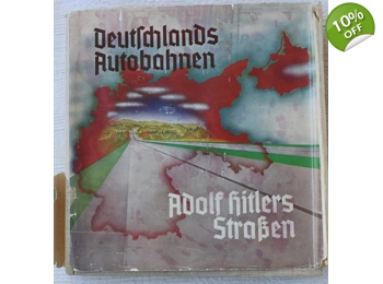
1937 DEUTSCHLANDS AUTOBAHNEN - ADOLF HITLERS STRASSEN GERMANY'S FREEWAYS - ADOLF HITLER'S ROADS
Product Code: yE4aVKx
Rating: Be the first to write a review
Product Condition: Used
Deutschlands Autobahnen - Adolf Hitlers Straßen (Germany's Freeways - Adolf Hitler's Roads) was published in 1937 by the Nazi Party's Gauverlag Bayrische Ostmark in Bayreuth on the authority of the man in charge of developing and building the freeway system in Nazi Germany, Dr. Fritz Todt, the Generalinspektor für das deutsche Straßenwesen (Inspector General of German Highways). The hardcover book measures 8-1/2 x 9 inches and the 278 pages are absolutely full of spectacular photographs and color maps! With an original dustjacket!
This First Edition of Deutschlands Autobahnen - Adolf Hitlers Straßen starts with a full-page portrait of Adolf Hitler (the creator of the enormous Nazi freeway project) followed by a full-page portrait of Dr. Fritz Todt (the builder of the Reichsautobahnen). The thought behind the freeway system is explained, then developing real plans from the original ideas, planning to fit freeways into German scenery, the labor force for the building of the freeway system, housing and feeding the labor force, laws regarding street and highway designations, alpine roads, fuel, the motorization of Germany, foreign travel, etc., etc.
The enormous progress of building the Reichsautobahnen between 1 May 1933 and 19 December 1936 is covered as well as the new laws regarding the freeway system.
The last section of the book contains 16 very accurate COLOR fold out maps of the Reichsautobahnen in Nazi Germany. The sections are Bremen-Hamburg-Lübeck, Berlin-Stettin, Elbing-Königsberg, Hannover-Berlin, the Berliner Ring, Köln-Ruhrgebiet, Hall-Leipzig-Bayreuth, Glauchau-Dresden, Kreibau-Breslau, Ban Nauheim-Bruchtal, München-Salzburg, Schwarzwalderhöhenstrasse, Bayerische Ostmark and the Deutsche Alpenstrasse. Some of the color maps are as large as 9 x 42 inches!
$700.00
$630.00 inc. tax
Customer Reviews
No Reviews Posted Yet - be the first! (write review)


